A new ability to look within a storm and see its components was put to the test July 15 when a tornado tore a path through southeast Barrie.
“We have a brand-new radar at King and no sooner was it put in operation than this event took place and we managed to capture it,” said Daniel Michelson, a research manager at Environment and Climate Change Canada’s radar facility in King City, about 60 kilometres south of Barrie. “What we have is the ability... to look at storms and get a lot more information.
"And greater ability to distinguish between a severe storm and a non-severe storm," he added.
Michelson, who works at the Observation Based Research Section in King City where the first radar was installed in 1984, said the new dual polarization radar allows forecasters to see the shape and size of the physical elements of a storm.
“It gives us the ability to distinguish particles and drops, different shapes. Larger drops are not spherical and so we can see the difference between the horizontal and vertical channels and be able to distinguish those, but it also gives us the ability to distinguish between the raindrops and other features related to these storms,” said Michelson.
Although it remains very difficult for a forecaster to identify a storm that can be producing a tornado, he added.
The dual polarization radar installed at King City went live just two weeks before a thunderstorm produced a series of EF2 tornadoes around and north of Lake Simcoe on July 15, following a northeasterly path from Barrie.
For researchers like Michelson, as well as Environment and Climate Change Canada’s meteorologists, it was their first chance to see this type of detail inside a tornado. Through the dual polarization, they were able to see not just the wind direction, but also the horizontal and vertical shapes of the rain drops as well as the debris tossed airborne by the twister.
The super cells that produce these storms are much larger than the tornado itself and produces signatures that Michelson describes as a hook echo — an often short-lived pattern like a small hook, which indicates the possibility of a tornado inside it.
“There was a nice hook in this case. And the wind gave us... a very typical signature that indicates some vorticity. That gave the forecaster confidence as well to be able to make a decision to make a warning,” he said.
Northern Tornadoes Project (NTP) executive director David Sills says the key is that forecasters can actually see tornado debris in the air with the radar. The dual polarization examines the elements both horizontally and vertically to provide shape information and allows forecasters to distinguish between raindrops, hail and debris.
“Now we can look at an image from the new radar and actually tell the tornado is occurring just by the fact that there is debris in the air over the area of rotation and we could actually see that with the Barrie tornado. This is something that is a new capability,” said Sills.
“It’s only tornadoes that can loft debris high enough that you can see them with the radar," he added. "Once you see that, you pretty much know you have a tornado.”
Originally, radar showed the precipitation. Then in the 1980s Doppler radar allowed experts to see how the precipitation was moving within the storm and see rotation, often the precursor to tornadoes. It hadn’t yet gone operational in time to capture the events surrounding the deadly 1985 series of tornadoes that tore through Barrie and central Ontario
“Now we’ve got this next step of this dual polarization capability where we can actually see the shape of what the radar is detecting. So now we can tell the difference between light rain, heavy rain, hail, insects and tornado debris,” said Sills.
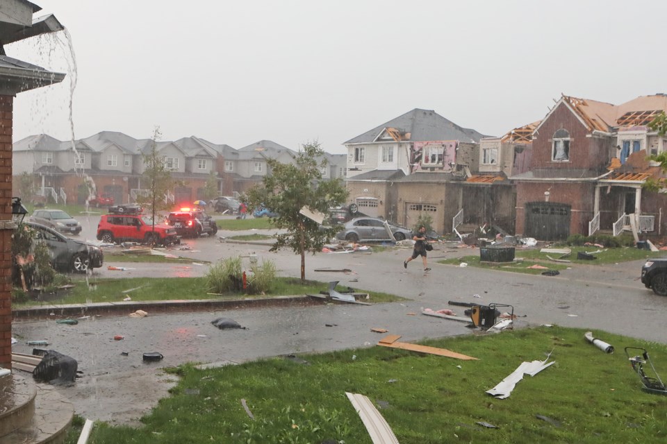
The insured damage caused by the series of EF2 tornadoes on July 15, one of which devastated the south-end Barrie neighbourhood around Prince William Way and Mapleview Drive East, has been pegged at about $75 million, according to the Insurance Bureau of Canada.
Initial estimates of the damage caused in Barrie, Innisfil, Kawartha Lakes, Little Britain, Manilla, Lindsay, and Lake of Bays come from Catastrophe Indices and Quantification (CatIQ).
The damage was most significant in Barrie, however, where officials issued 70 unsafe orders for local homes, meaning those houses couldn’t be accessed. Residents of 41 of those homes were recently allowed to go in.
In Barrie, 11 people were taken to the hospital with injuries — two of them were admitted, but were released that weekend.


