All the normal warning signs weren’t there for the EF-2 tornado which roared through south-Barrie Thursday says David Phillips, Environment and Climate Change Canada’s senior climatologist.
“The first indication of severe weather is nature. There’s no sneak attacks in weather like this, no surprises really,” he said. “(Thursday) had some surprises.
“It wasn’t ominous, it didn’t scare the beegeebies out of me when I looked at that sky,” said Phillips, who lives in Barrie’s downtown. “The thing I most remember is hearing non-stop sirens for about 20 minutes - paramedics, police and fire, heading somewhere south where obviously the tornado or something had struck.
“I didn’t think necessarily to tornados because I didn’t think the sky was angry enough,” he said. “So I think that sometimes people maybe could have been caught off guard.”
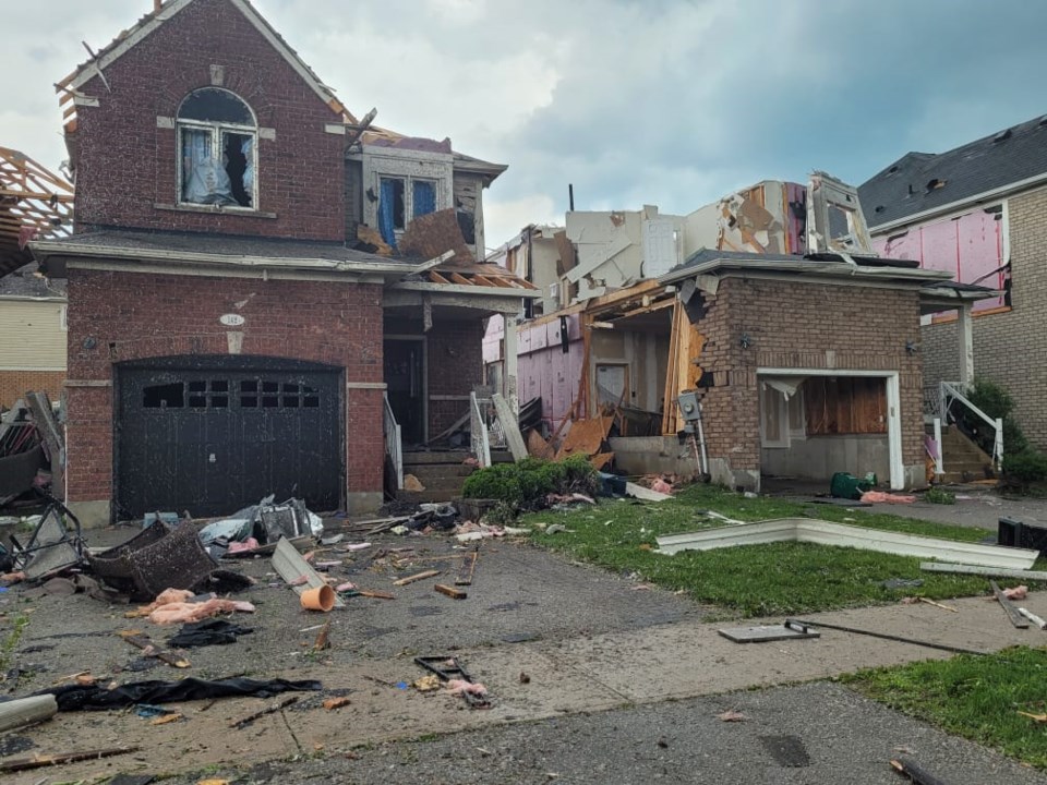
The tornado reached wind speeds of 210 kilometres an hour, said Environment and Climate Change Canada (ECCC), and with a damage track about five kilometres long and 100 metres wide, destroyed some homes, tore the roofs off others, flipped vehicles and injured 11 people.
“This could have been so much worse,” said Barrie Mayor Jeff Lehman on Twitter Friday morning. “(It’s) just incredible that we didn’t have more severe injuries.”
Thursday’s tornado was this week’s second severe storm in Barrie. On Tuesday evening, the city’s rain gauge system measured between 35 and 60 millimetres of rain across Barrie in about 90 minute - nearly overwhelming the stormwater system.
Phillips is a veteran of severe weather, especially in the Barrie area. He remembers the 1985 tornado and the Angus tornado in 2014.
Thursday’s storm was different.
“Back in 1985, the sky was green, it was boiling, it was dark, it was ominous, you just knew you had to turn your lights on and then it happened,” he said. “Angus too. There were all kinds of indications that something was going to touch down, but (Thursday) it was almost a sneak attack. It was almost as if people had been caught off guard.”
Steven Flisfeder, warning preparedness meteorologist with ECCC, said it uses Doppler radar to detect rotating winds and identify tornados.
“That is one of the things that informed the decision to send the tornado warning (Thursday), was rotation being detected within the storm,” he said.
“The storm watches and warnings were out (at) 2:28 (p.m.) I got on my cell phone a severe thunderstorm warning,” Phillips said, “for Barrie and Collingwood and Hillsdale, and imbedded in that, if not even said explicitly, is often a tornado. It talks about the heavy rain, torrential rains, strong winds about 90 (km/h), big-sized hail balls and of course the risk of a tornado.
“And then at 2:38 that was upgraded to tornado warning. I don’t know if that’s exactly when the tornado occurred, some people thought a little before, some a little after.”
A tornado watch means there’s a good chance that a tornado will form in the affected area, while a tornado warning means a tornado is occurring, or about to happen, and people in the area should immediately take cover.
Phillips said just the right, or wrong, combination of conditions created Barrie’s tornado Thursday afternoon.
“The dynamics were there,” Phillips said. “We had a lot of rain over several days, so every time the sun would come out, it would be evaporating that moisture into the air. You know the crops are growing feverishly at this time. They transpire moisture into the air, which ... is a fuel to these severe thunderstorms.
“You also have…the so-called lake breeze, off of Lake Huron and Georgian Bay, is enough of a push for all that warm, humid air that rises. And then at the same time, we were getting the final straw, which was a cold front,” he said. “Then it gets clouds rotating, moving in different directions, kind of just gives a little bit of a juice to an atmosphere. So then misery is going to break out somewhere.
“We had severe thunderstorm warnings from Shelbourne and North Dufferin County to Barrie to Hillsdale to Orillia, Washago, Innisfil, New Tecumseth. That little touchdown could have been anywhere in that geography,” Phillips said. “It just happened to be in Barrie.
“If it occurred a few kilometres further to the east, well it might knock down a tree or blow up some dust, but it wouldn’t have destroyed any neighbourhoods. This hit a neighbourhood, a densely populated neighbourhood and that’s why it’s the headline today.
“We wouldn’t even be talking about if it had hit a couple of kilometres away,” he said.
Phillips noted the incidence of tornados isn’t increasing, but the chances are greater for damage because there are more targets to hit - houses, sheds, buildings, automobiles, etc.
He noted that 10 per cent of tornados are EF-2 or above, so 90 per cent of them are EF-0, or EF-1.
An EF-0 tornado has wind speeds of 90-130 km/h, EF-1 is 135-175 km/h, EF-2 is 180-220 km/h, EF-3 is 225-265 km/h, EF-4 is 270-310 km/h and EF-5 is 315 km/h and higher, says ECCC.
“This one is estimated at 210 km/h so it’s sort of the high end of an EF-2, so that’s significant and when you look at the damage and what the scale tells you,” Phillips said.
EF-2 means roofs torn off of well-constructed houses, foundations of frame houses shifted, mobile homes completely destroyed, large trees snapped or uprooted, cars lifted off the ground or rolled, but not tossed, and light-object missiles generated.
“What gets you in tornados is not the winds, but wind-filled debris. Projectiles,” Phillips said. “Stones are like bullets and lumber is like spears. That’s when you see most of the injuries. They are moving at such speeds.”


