A wall cloud forced down torrents of rain, hail in spots and there were reports of a weak mesocyclone moving northeasterly from southern Ontario last Sunday.
It followed a path similar to a series of deadly tornadoes known as the Barrie Tornado just a week shy of its 35th anniversary.
This time, though, advanced technology and science allowed severe weather experts to issue a tornado warning.
With advance notice, many eyes turned to the skies and storm chasers raced out in search of the possibility of that meteorological wonder where unstable air in a low-pressure area rises rapidly, creating a column of rotating air that, when touching the ground, can rip apart anything in its way.
A Twitter storm soon erupted, resulting in some stunning photos and videos of the unique cloud formations. Any twisters that did develop last Sunday, however, remained aloft and the only damage was caused by rain and flooding.
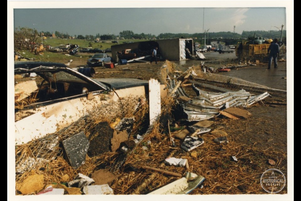
MAY 31, 1985
Thirty-five years ago today, in 1985, there was no social media allowing strangers to share information from different geographic locations.
There wasn’t even much advance warning as an unrelenting storm moved north from the United States, going northeasterly though Ontario where it created a series of tornadoes and separate suction vortices spinning out from the main twisters as they skipped across southern Ontario, ripping through small towns and rural areas and sometimes jumping aloft and then hitting the surface again.
By about 5 p.m. that Friday afternoon, four people had already been killed and the centre of Grand Valley was a mess as a tornado ensconced in rain then took a firm hold of the ground, working its way into Barrie from the southwest, cutting a destructive path across the city and taking another eight lives.
“We received no reports of any damage (or) any big hail. We really did not have any real confirmation of what was going on on the ground,” recalls Mike Leduc, who was heading up Environment Canada’s severe weather desk that day.
“I think the first reports that we got that something was really bad was from Barrie at 5 o’clock. Before that, we didn’t know what was going on on the ground,” even though Grand Valley had been severely hit an hour earlier.
“We didn’t know how bad it was.”
A weather watcher network would be developed soon after the Barrie Tornado, along with groups of storm watchers.
In 1985, the best officials could hope for was hearing from people on the ground experiencing the storms.
But there were no calls.
The scientific knowledge and the technological tools were also limited back then. There was no real ability to discern a typical severe thunderstorm situation from a tornado. And there was no way to see the potential for a major outbreak.
Forecasters now have the tools and knowledge to see the development of wind shear and how the winds change with height in the atmosphere, something that was only starting to develop in the 1980s.
Even just a year after Barrie, with some updated techniques, forecasters were able to issue a tornado watch a little farther west in Minden.
But in 1985, the best forecasters could do was issue severe thunderstorm watches for Barrie. That morning, there had already been some heavier storms with wind, rain and some hail. At about 1 p.m., the main line came in.
“Watches for severe thunderstorms that included Barrie were in effect even in midday that day. So the storms got going at about one o’clock and it was pretty obvious right away that they were severe thunderstorms, so there were warnings issued for severe thunderstorms at one o’clock for the Bruce Peninsula and eventually moving east,” says Leduc.
“Barrie probably happened right at the end of a period when we were not very good at forecasting tornadoes at all. Unless we had a report, we didn’t really know when there were tornadoes on the ground.”
One year earlier, a Doppler radar was installed in King City, but it hadn’t yet been fully implemented to be of use on May 31, 1985. A year earlier, Leduc also started to see research on wind shear, when the wind changes with height, which is now a regular consideration in severe weather watching.
TODAY’S TECHNOLOGY
“Doppler radar is used extensively now to detect thunderstorms that may produce a tornado because it detects movement of the rain,” explains Dave Sills, executive director of the Northern Tornadoes Project at Western University in London, whose goal is to document all tornadic activity in Canada, even where there is no population base.
“Back then, it was thought that as long you knew the storm was rotating, there was a good chance that it was also producing a tornado," Sills adds. "Now that we have more experience with Doppler radar, we know there are quite a few storms that rotate but that do not produce tornadoes.”
While the Great Lakes tend to suppress thunderstorms and tornadoes, that strip of land between them extending from Windsor to Barrie creates a corridor for more focused severe weather, allowing for tornadoes.
“A lot of new things came in because of the tornadoes in Barrie and then in Edmonton a couple of years later,” says Leduc.
Those tragic tornadoes provided the impetus to get better weather radio, develop the storm watchers' network and then getting Doppler radar set up across the country, he adds.
If a storm is rotating, weather experts can determine the velocity pattern through Doppler radar and can infer through the type of air movement detected if there’s rotation with the storm.
Satellite images have also been vastly improved, partly thanks to weather satellites launched by the U.S. National Aeronautics and Space Administration and National Oceanic and Atmospheric Administrations.
Previously, low-resolution satellite data would come in every half hour and were printed to create some basic animation of the movement of the air.
They now have far higher resolution with new images coming in more frequently and available in seconds on the computer screen, helping the forecaster to determine how the storms occur and how they will behave in the next hour or two.
Weather balloons, adds Sills, are still launched twice daily and are an important source of data for computer models. Weather modelling has historically used some of the largest computers to calculate formulas, allowing weather experts to see the ingredients of a storm come together to develop a picture of what is anticipated in coming minutes, hours and days based on the known science of how air will move.
New dual-polarization radar in King City also shows different shapes which allow experts to tell the difference between raindrop, versus hail, versus snow and not just precipitation, says Environment Canada’s Gerald Cheng, the warning preparedness meteorologist for southern Ontario.
And he points to cellphone technology, which allows automatic notification to people who may be affected.
“The dissemination process, that is a big change compared to what we had 30 years ago,” he said.
Canada’s emergency Alert Ready System disseminates warnings through cellphones in a specific geographic area; it has been most frequently used for Amber Alerts. As long as the phone is compliant with the system, the warnings cannot be bypassed. That was used in the fall of 2018 to warn residents in the Gatineau-Ottawa area of a tornado.
There are also several apps available designed to send weather notifications.
And social media is replacing those older networks in the hierarchy of communications tools.
“Social media has been a game changer, because everybody can share their experience of weather. And now we have pictures and videos instantaneously posted on social media,” Cheng says.
Cheng and his colleagues at the Environment and Climate Change Canada’s weather offices sift through the noise to monitor on-the-ground reports identified through #onstorm about specific weather events.
That real-time information, often including photos, videos and descriptions, can serve as the eyes and ears in relaying what’s happening under the storm, beyond what radar allows.
“That really increases the number of sets of eyes across the province,” he says. “In the past, it was phone conversation. And you can imagine it was very labour intensive” to answer every call. “Now we just look up at these different tweets and we get a sense of what is out there.”
Weather specialists do carefully sort through that intelligence, ensuring anything of interest is substantiated through their own data sources. There have been occasions where old photos were posted in new conversation streams, for instance.
Sills says the science now exists to provide 10 to 15 minutes warning for events like the rotating super cell storms that created catastrophic damage on parts of Barrie and claimed a total of 12 lives in central Ontario 35 years ago.
But there are still hybrids or activity that aren’t as obvious on radar and continue to be difficult to detect.
“Sometimes you get no lead time on those,” he says. "All you do is hear the call come in and have a bad feeling that you missed it.
“It depends on the kind of storm.”


